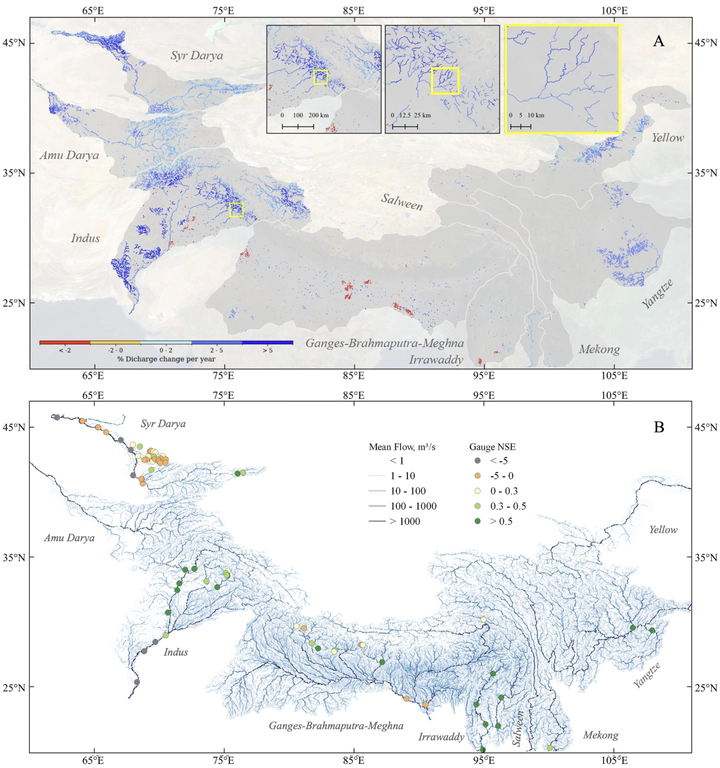
 Spatial patterns of river discharge for ∼114,000 reaches across 9 HMA basins. (a) significant ( p‐value <0.05)trends in mean annual river discharge from 2004 to 2019. Only reaches with significant changes are shown. Inset maps showriver reaches near Maharana Pratap Sagar reservoir in Northern India and illustrates the spatial resolution of the study.(b) Mean discharge for the study period as well as the model performance in terms of Nash‐Sutcliffe efficiency (NSE).
Abstract
High Mountain Asia (HMA) plays a crucial role in Asian hydrology—its vast snow and glacier-covered landscape significantly influences downstream river water supply for billions of people. Understanding the spatiotemporal pattern of river discharge in HMA aids effective water resource management and infrastructure planning. In this study, we used a combination of hydrologic modeling and assimilation of remotely sensed discharge from Landsat and PlanetScope imagery to investigate how daily river discharge has changed for more than 114,000 reaches across HMA between 2004 and 2019. We observed significant increasing trends in river discharge for 11,113 reaches (∼10%), particularly in smaller rivers of the Syr Darya, Indus, Yangtze, and Yellow River basins. The ratio of total glacial melt and precipitation received by individual river reach showed an average significant increase of 2.2% per year, particularly in the Syr Darya, Amu Darya and Western Indus rivers. Across HMA, our results also indicate that 8% of river reaches with either planned and existing hydropower plants or dams experienced a statistically significant average increase of 2.9% per year in stream power. These findings illustrate the rapidly changing patterns of river discharge and stream power in HMA.