Remote Sensing

Spiralling frontier threats in Indigenous Amazonia
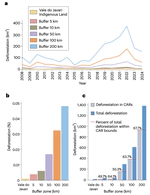
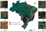
Indigenous Lands hold back Amazon deforestation, yet Brazil’s buffer-zone protections cover conservation units and not Indigenous territories, exposing their edges to extraction and drug trafficking. Satellite forest-loss records from 2008 to 2024 were compared inside the Vale do Javari Indigenous Land, noted for its tri-border setting and its large population living in voluntary isolation, and in zones out to 200 kilometers. Clearing there surged from 2017 to 2022, in 2022 running nearly 187.5 times the loss inside the territory, and 64% fell within holdings on the national rural land registry, misused to claim public land. It eased in 2023 and 2024 yet stayed well above the previous decade.
Spiralling frontier threats in Indigenous Amazonia
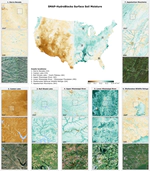
High-Resolution Soil Moisture Data Reveal Complex Multi-Scale Spatial Variability Across the United States
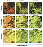
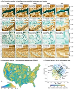
Soil moisture (SM) space and time variability critically influences freshwater resources, agriculture, ecosystem dynamics, climate and land-atmosphere interactions, and it can also trigger hazards such as droughts, floods, landslides, and aggravate wildfires. Here, we present the first continental assessment of how SM varies at the local scales using SMAP-HydroBlocks. This study maps the SM spatial variability, characterizes the landscape drivers, and quantifies how this variability persists across larger spatial scales. Results revealed striking SM spatial variability across the United States. However, this SM variability does not persist at coarser spatial scales resulting in extensive information loss. This information loss implicates inaccuracies when predicting non-linear SM-dependent hydrological, ecological, and biogeochemical processes using coarse-scale models and satellite estimates.
High-Resolution Soil Moisture Data Reveal Complex Multi-Scale Spatial Variability Across the United States