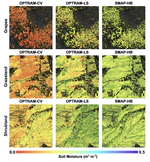
Optical satellite methods infer soil wetness from surface reflectance and greenness, filling the gap left by coarse resolution microwave sensors. Calibrated once for a whole region, they are biased toward the dominant land cover; calibrating separately by land cover class offers a way around that. We show that vegetation-type specific calibration on California’s Central Valley cut average soil moisture estimation error from 0.09 to 0.05 cubic meters per cubic meter and resolved individual fields and water pathways.