High-resolution (1 km) Köppen-Geiger maps for 1901–2099 based on constrained CMIP6 projections
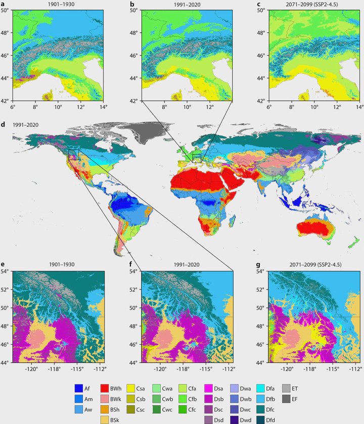 Köppen-Geiger classification for the European Alps (a–c), the global land surface (d), and the central Rocky Mountains (e–g) for 1901–1930 (a,e), 1991–2020 (b,d,f), and 2071–2099 (c,g) under the SSP2-4.5 scenario. In panels a–c the white areas are the Mediterranean Sea, with all seas and oceans being white in panel d.
Abstract
We introduce Version 2 of our widely used 1-km Köppen-Geiger climate classification maps for historical and future climate conditions. The historical maps (encompassing 1901–1930, 1931–1960, 1961–1990, and 1991–2020) are based on high-resolution, observation-based climatologies, while the future maps (encompassing 2041–2070 and 2071–2099) are based on downscaled and bias-corrected climate projections for seven shared socio-economic pathways (SSPs). We evaluated 67 climate models from the Coupled Model Intercomparison Project phase 6 (CMIP6) and kept a subset of 42 with the most plausible CO2-induced warming rates. We estimate that from 1901–1930 to 1991–2020, approximately 5% of the global land surface (excluding Antarctica) transitioned to a different major Köppen-Geiger class. Furthermore, we project that from 1991–2020 to 2071–2099, 5% of the land surface will transition to a different major class under the low-emissions SSP1-2.6 scenario, 8% under the middle-of-the-road SSP2-4.5 scenario, and 13% under the high-emissions SSP5-8.5 scenario. The Köppen-Geiger maps, along with associated confidence estimates, underlying monthly air temperature and precipitation data, and sensitivity metrics for the CMIP6 models, can be accessed at www.gloh2o.org/koppen.