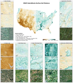
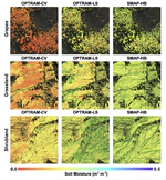
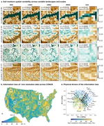
Drought monitoring and yield prediction often rely on coarse-scale hydroclimate data or (infrequent) vegetation indexes that do not always indicate the conditions farmers face in the field. Consequently, decision-making based on these indices can often be disconnected from the farmer reality. Our study focuses on smallholder farming systems in data-sparse developing countries, and it shows how field-scale soil moisture can leverage and improve crop yield prediction and drought impact assessment.
The first hyper-resolution satellite-based surface soil moisture dataset at 30-m resolution over the continental United States
Drought monitoring and yield prediction often rely on coarse-scale hydroclimate data or (infrequent) vegetation indexes that do not always indicate the conditions farmers face in the field. Consequently, decision-making based on these indices can often be disconnected from the farmer reality. Our study focuses on smallholder farming systems in data-sparse developing countries, and it shows how field-scale soil moisture can leverage and improve crop yield prediction and drought impact assessment.
HydroBlocks is a field-scale resolving land surface model for computationally efficient applications over continental extents. Learn more on the model development & applications [here](../../HydroBlocks).
Information about the spatiotemporal variability of soil moisture is critical for many purposes, including monitoring of hydrologic extremes, irrigation scheduling, and prediction of agricultural yields. We evaluated the temporal dynamics of 18 …
Field-scale satellite observations, physical models, and machine learning combined can enable crop yield prediction at high spatial resolution at data-scarse regions. Learn more about it [here](research/crop_yields_zambia).
Soil Moisture (SM) is a direct measure of agricultural drought. While there are several global SM indices, none of them directly use SM observations in a near-real-time capacity and as an operational tool. This paper presents a near-real-time global …
Accurate and detailed soil moisture information is essential for, among other things, irrigation, drought and flood prediction, water resources management, and field-scale (i.e., tens of m) decision making. Recent satellite missions measuring soil …
Given the varying manifestations of climate change over time and the influence of climate perceptions on adaptation, it is important to understand whether farmer perceptions match patterns of environmental change from observational data. We use a …