2
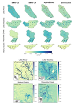
Satellite missions measuring soil moisture from space continue to improve the availability of soil moisture information. However, the utility of these satellite products is limited by the large footprint of the microwave sensors. This study presents a merging framework that combines a hyper-resolution land surface model (LSM), a radiative transfer model (RTM), and a Bayesian scheme to merge and downscale coarse resolution remotely sensed hydrological variables to a 30-m spatial resolution. The framework is based on HydroBlocks, an LSM that solves the field-scale spatial heterogeneity of land surface processes through interacting hydrologic response units (HRUs). Our approach was demonstrated for soil moisture by coupling HydroBlocks with the Tau-Omega RTM used in the Soil Moisture Active Passive (SMAP) mission. The brightness temperature from the HydroBlocks-RTM and SMAP L3 were merged to obtain updated 30-m resolution soil moisture estimates.